
Liam Baker.

Software Engineer

Save my details
Liam Baker

I build web, mobile and data-intensive software, combining hands-on engineering with product ownership and technical leadership. Since starting freelance work in 2018, I’ve worked across application architecture, shared services and production operations.

I take ownership of product decisions, working with clients, engineers and business leaders to turn competing requests into a clear plan. I weigh user needs against technical constraints, dependencies and the team’s capacity.
I provide technical direction and work alongside other engineers on implementation. I break down complex work and mentor through pairing and code review, helping colleagues develop their own solutions.

Applications
Interface architecture, complex workflows, authentication, live-data migration and native integration.
Backend & data
API and domain design, relational and spatial databases, asynchronous processing and real-time delivery.
Cloud & delivery
Reproducible environments, deployment automation, observability and production diagnosis.
Applied AI
Model evaluation, retrieval, structured generation and validation within application workflows.

Selected work.

React Native · iOS + Android

Mobile platform engineering

I owned the mobile platform across iOS and Android, from application development and backend integration to identity and production delivery.

The React Native application launched in 2021 after approximately four months of development and later supported 3,500 monthly active users.

Platform responsibilities

Application foundation

Built navigation, core workflows and internationalisation in React Native. Extended Expo into native iOS and Android layers and resolved library integration issues.

User continuity

Preserved live data and existing login methods through a simultaneous application and backend transition, using Firebase account linking to reconcile previously disconnected identities.

Operational ownership

Managed app-store rollout and the production GCP/Firebase setup, reviewing backend changes that affected mobile behaviour and release quality.

Workflows · traceability

Enterprise workflow automation

I designed and led delivery of workflows that reduced thousands of individual planning actions across a team to a handful of supervisor clicks.

Supervisors could apply a template to a collection, generating schedules and assigning work across its applicable members in one operation. Task lists and Kanban views supported execution, with traceable links back to the source plan.

One template. Applied across the collection.

A season containing crop zones. One template generates activities for each member relative to its own planting date, retaining the shared template source. The three activity offsets are day zero, 14 days and 35 days.

Requirements, design and delivery

Translated operating needs into user journeys, system requirements and prototypes. I agreed the architecture with technical leadership, led implementation, and used staged client reviews and sign-off to keep scope, delivery and QA aligned.

Independent alphaDjango · PostgreSQL · LLMs

ThreadSense

I designed and built ThreadSense, an independent AI reporting alpha that turns fragmented communications into structured, source-linked findings for investigation and review.

Built with Django and PostgreSQL, it separates ingestion, conversation grouping, model-provider integration and report validation.

Generation & validation

Structured generation

Built schema-constrained model-provider integration with timeout, error and usage handling, plus validation of source references and reporting periods.

Review and retention

Added evaluation tooling for usefulness, source grounding and review burden, with configurable retention of source content.

PWA · APIs · telemetry

Machine telemetry and automation

I owned product definition and frontend delivery for a progressive web app combining bookings, machine telemetry and work verification, collaborating with backend engineers on API changes.

In 2024, I delivered the new frontend in approximately two months. We moved application-specific requirements into an existing core API, retired the overlapping API and retained the Google Cloud infrastructure.

Integration & automation

Live telemetry

Integrated three machinery-data providers through a common representation and shared processing layer, supporting real-time movement and fuel usage without exposing provider formats in the interface.

Work estimated from tracks

Used machine tracks to approximate worked area for irregular fields and fields with maintained areas, where parcel area could misstate completed work. Partial completion informed verification and area-based costing.

Automatic activity capture

Later, parcel-entry detection created work activities automatically. Users could arrange bookings elsewhere and still receive tracking and work history without manual activity entry.

NASA FIRMS · OpenLayers

Fire-hotspot monitoring

I developed satellite monitoring software to help investigate crop-residue burning under Thailand’s no-burn policies.

The work combined NASA fire detections, spatial search and interactive maps with workflow design for field-level review and follow-up.

Data, maps & investigation

Satellite data to map

Used NASA FIRMS data through Google Earth Engine, with clustered views of overall fire activity and drill-down into individual areas, size and intensity.

Frontend and spatial delivery

Integrated signed vector-tile endpoints with spatial and date filters. OpenLayers provided vector-tile rendering and zoom-dependent styling.

Compliance workflow

Defined how reviewers could link detections to nearby fields, investigate potential breaches and inform follow-up and payment eligibility decisions.

Machine learning · Data engineering

Predictive modelling and data pipelines

I built a reproducible pipeline processing more than 200 million field-level satellite observations across three growing seasons.

The retrospective MSc research combined satellite imagery, weather and field geometry to forecast field-condition deterioration five days ahead, from acquisition and modelling through reproducible inference and an interactive application.

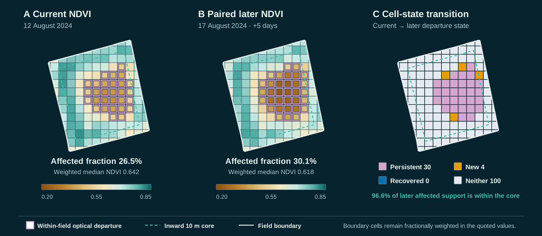
01 / Five days in one fieldEnlarge ↗
Satellite observations of the same field on 12 and 17 August 2024, with vegetation greenness maps and a third panel showing where conditions changed.
Measuring change inside a field

Two satellite observations, five days apart. The colours show vegetation greenness, measured by NDVI. The third panel shows which areas became affected, stayed affected, recovered or remained unaffected.

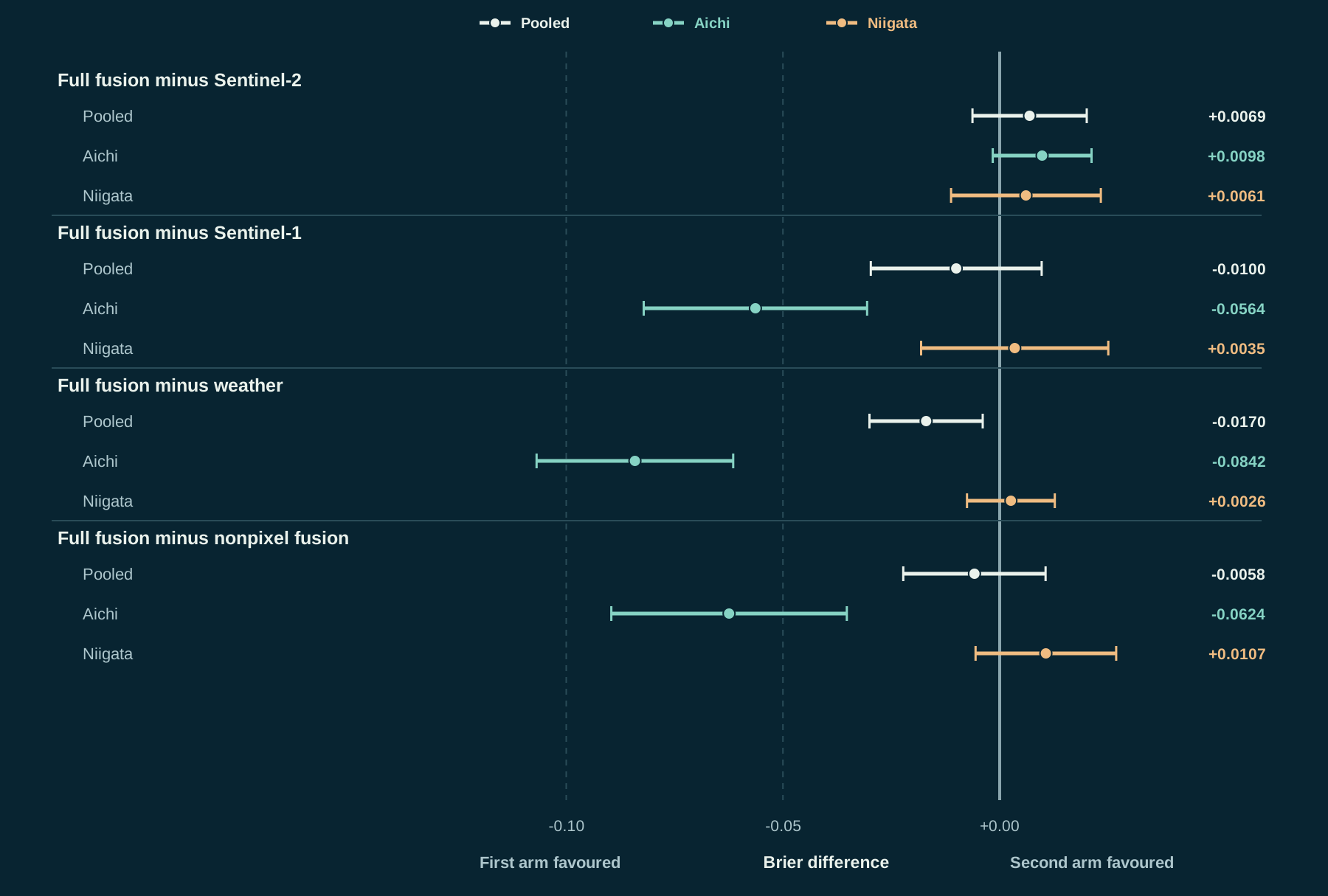
02 / Comparing the modelsEnlarge ↗
Four comparisons of prediction error, overall and by region. Points show differences between models; lines show 95% uncertainty intervals. Negative values favour the first named model.
Does combining data improve prediction?

Combining satellite and weather data improved probability estimates over weather alone in the overall comparison. It did not show a clear advantage over Sentinel-2 imagery alone. The chart compares prediction error using Brier score: negative values favour the first model, and the lines show 95% uncertainty intervals.

Data, evaluation & application

Data pipeline

Processed satellite observations with column-oriented storage and reusable pipeline outputs, making large-scale experiments repeatable.

Temporal evaluation

Developed models on 2022–2023 data and tested five satellite and weather configurations on 6.24 million field-date examples from 2024, keeping calibration separate from final evaluation.

Research application

Built a full-stack platform for regional-to-parcel exploration, historical planting timelines, interactive filters and shareable maps, supported by spatial APIs and vector tiles.

Inference and inspection

Built an inference demonstration covering 7,287 fields and a separate inspection-priority workflow using current anomalies, data quality, crop stage and weather.

02 / ENGINEERING

Systems & delivery.

Reliability

Production diagnosis & delivery

I diagnosed production failures across mobile applications and shared backend services.

API performance

Profiled repeated database queries and other bottlenecks, reducing p95 latency for field-data requests by 40%.

Native crashes

Traced Android failures through incomplete native logs and device/OS differences. Targeted fixes reduced the crash-affected session rate by 10%.

Delivery environments

Owned mobile release automation and Firebase configuration; co-developed reproducible cloud delivery with GitLab CI/CD, Docker and encrypted configuration. Automated builds and deployment replaced a day-long process with an approximately one-hour pipeline.

Team delivery

Introduced Agile/Kanban planning and shared release documentation in GitLab, and helped secure dedicated part-time QA support.

Backend systems

Shared services & data

I contributed to shared Rails services backed by PostgreSQL and PostGIS.

Access & live data

Contributed to organisation-scoped APIs and data models, authenticated WebSockets and viewport-driven vector-tile endpoints.

Asynchronous ingestion

Contributed to satellite ingestion across 100,000 fields: historical backfills, quality checks and Pub/Sub workers with transactional updates and completion acknowledgements.

Retrieval integration

Co-developed activity suggestions using similarity search, organisation-specific context and validated structured responses.

Interactive maps

Rendering & performance

I led development of map interfaces for analysing tens of thousands of entities across five analytical layers, shortening map-loading times by approximately 30%.

Rendering lifecycle

Custom OpenLayers WebGL loading and per-image state coordinated imagery swaps, reduced flicker and prevented redundant layers.

Viewport loading

Combined caching, debouncing, batching and spatial clustering to control data loading across zoom levels.

Schema evolution

Extended the soil-analysis interface and state model from one sample per parcel to multiple samples.

Engineering approach

AI-augmented engineering

I direct AI-augmented investigation, planning, implementation and review, retaining responsibility for architecture, integration and acceptance.

Task design

I give specialist agents bounded tasks, relevant context and clear ownership, coordinating parallel work through worktrees and concise handoffs.

Independent review

I separate implementation from review and assess changes against requirements, tests and source evidence, managing context and token budgets with explicit retry limits.

03 / EXPERIENCEEducation

Experience.

April 2021–Present

ListenField Inc.

Full-Stack Engineer

Web, mobile and shared-platform software for agricultural businesses and enterprise clients.

2020

Xenon Partners

Software Engineer

Delivered customer-facing React components and modernised payment integration.

2020

Growing Trees Inc.

Website Consultant

Website and internal database improvements informed by customer feedback.

2019

Odaiba

Full-Stack Engineer

Built web features, including scheduling across time zones, and improved API performance.

2019

Le Wagon

Programming Teaching Assistant

Taught web development, coached projects and reviewed interfaces.

2012–2019

LT International School

Elementary School and Campus Head Teacher

Teaching, campus coordination, curriculum discussions, colleague development and parent communication.

Education.

2024

MSc Computer Science

University of Bath

2022

Project Management Certification

Google

2019

Full-Stack Coding Bootcamp

Le Wagon

2017

PGCEi, Education in International Schools

University of Nottingham

2012

BSc (Hons), Sports, Health, and Exercise Sciences

Loughborough University

THE TOOLKIT

Languages & tools.

Interfaces & applicationsReact · TypeScript · Next.js · React Native · Expo

Systems & dataRails · Python · PostgreSQL / PostGIS · APIs · WebSockets · DuckDB · Parquet

Applied AIData pipelines · model evaluation · probability calibration · retrieval · structured generation

Delivery & diagnosisGCP · Firebase · GitLab CI/CD · Docker · Nix · New Relic · Rollbar

04 / PERSONAL
The illustrated snowy mountains of Frostline.FROSTLINE / OFF THE CLOCK

Off the clock.

I like having a space of my own to think, learn and work on personal projects.

I enjoy snowboarding, spending time in the mountains and travelling to explore new places.

CONTACT

Get in touch.

Send a message or request my CV.

hello@jupiterslb.com
Send a message
CONTACT

Send a message.

Tell me what you’re working on and how I can help.

Your details are used to respond to your enquiry.

Request CV
CV REQUEST

Request my CV.

Share a little context. I’ll review your request and follow up by email.

Complete the spam check before requesting the CV.

Your details are used to respond to your CV request.

Profile tools

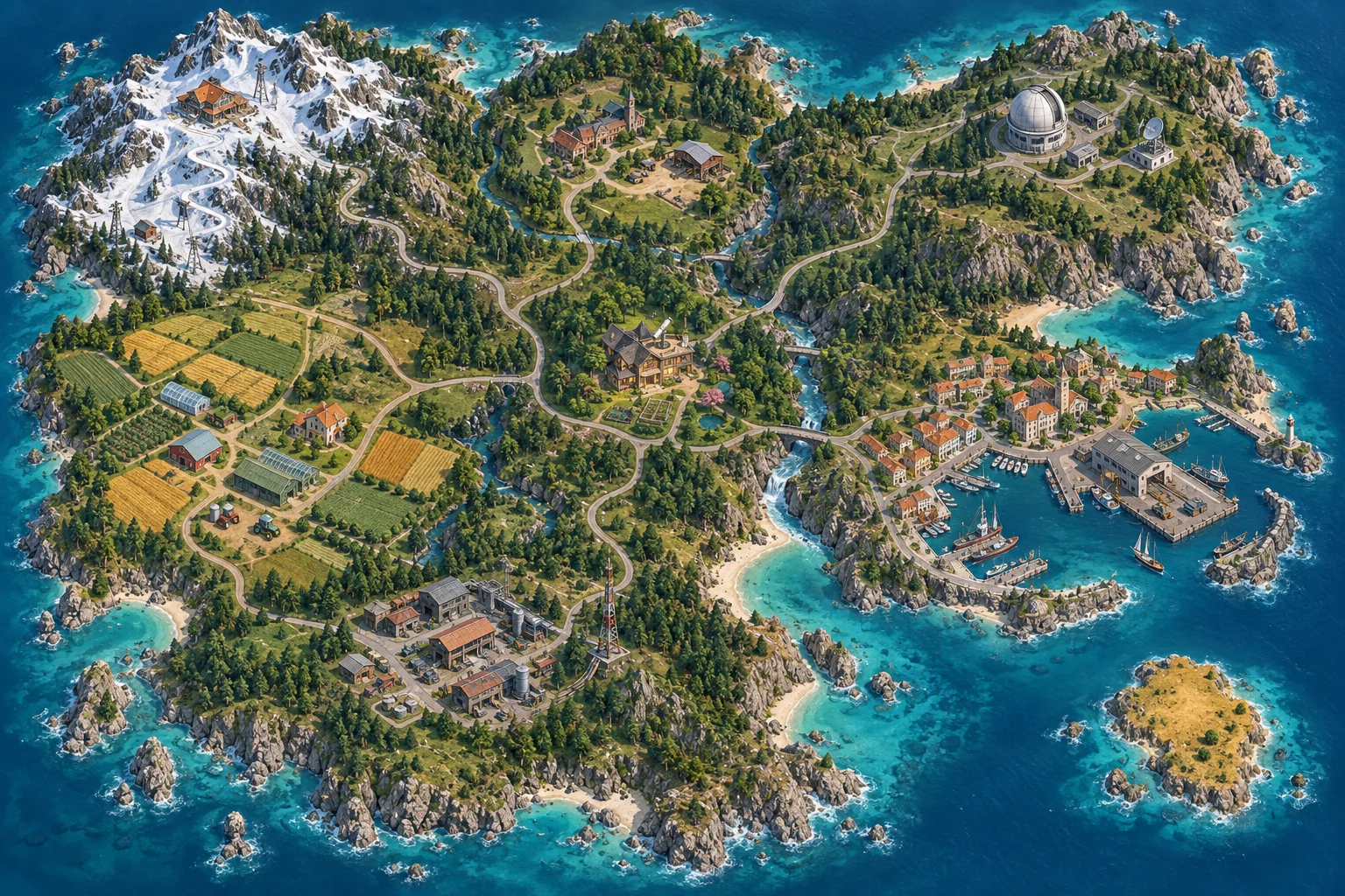
An illustrated island: snowy Frostline, agricultural Verdant, industrial Copperline, research campus Helix, harbor city Tidewater, learning village Lantern and the secluded home Meridian.
AURUMUncharted · markets & finance
ORBIT / LIAM BAKERReal stories. An imagined island.
Island overviewZoom in anywhere
OBSERVATION MODE
SATELLITE READYFind something interesting.Click the terrain or guide with W A S D.

Implementation notes

THE ISLAND ATLAS

Your discoveries.

Seven regions. Nineteen places.

Aurum is reserved for future markets and finance content.

A SMALL FIELD GUIDE

Follow your curiosity.

Zoom in for a closer look, then click the terrain or use W A S D to guide OS-01. A place stays hidden until the satellite window passes over it in a suitable imaging view. Try all three views: natural landmarks appear in any view; other signals need near-infrared or shortwave IR. Exposed places stay on your map and in the Atlas for this visit. Acquire a nearby signal to read its story. Zoom out for the regions. The Profile shows all the content in full. Each discovery links to its matching section.

Drag / swipe
Move around the island
Scroll / pinch / + −
Look closer or pull back
W A S D
Guide the satellite manually
1 · 2 · 3
Switch the satellite’s imaging view
E
Acquire a nearby signal
Escape
Return to the map
Real experience, illustrated geography.

The names, landscapes and spectral effects are illustrative. Spectral colour stays inside the satellite window, while the surrounding island stays in natural colour. Your imaging view reveals different authored signals; it does not make scientific claims about the locations. Career content is based on my experience. Progress lasts for this visit.